
The Skyscraper Museum is devoted to the study of high-rise building, past, present, and future. The Museum explores tall buildings as objects of design, products of technology, sites of construction, investments in real estate, and places of work and residence. This site will look better in a browser that supports web standards, but it is accessible to any browser or Internet device.
EARLY 18th CENTURY
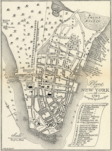
*The original Lyne map depicts NYC in 1730 and was published in 1731. This copy published in 1894 erroneously dates the map to 1729.
Thomas A. Janvier, In Old New York, 1854, pg. 36.
James Lyne's map of 1730* shows Wall Street's eclectic mix of development in the early 18th century. Four wholly dissimilar buildings stood between Broadway and William Street: the First Presbyterian Church, a tavern, City Hall, and Bayard's sugar house. One of the earliest major structures of the street, First Presbyterian Church was erected in 1719 on the north side between Broadway and Nassau Street and helped establish the new thoroughfare as a center of activity. The civic and social nature of the street continued with the tavern and with City Hall, constructed in 1703, then was interrupted by the sugar refining factory, which was built in 1730 on a large lot set back from Wall Street.
At five to seven stories, sugar houses were taller and more monumental than most contemporary buildings. The massive brick and stone structures with deep windows marked an intermediate stage between home factories of the 17th century and immense modern plants of the 19th century. Sugar has been an important commodity and industry in New York from colonial times, shipped and stored along the East River and managed from Lower Manhattan offices. The Bayard sugar house was located about halfway between William Street and City Hall as noted on the map at No. 6; today the seventy-story tower 40 Wall Street occupies the site. Sugar houses were considered large imposing eye-sores in contemporary days, which was especially true of the Wall Street sugar house, as it stood in such stark contrast with the neighboring civic buildings.