
The Skyscraper Museum is devoted to the study of high-rise building, past, present, and future. The Museum explores tall buildings as objects of design, products of technology, sites of construction, investments in real estate, and places of work and residence. This site will look better in a browser that supports web standards, but it is accessible to any browser or Internet device.
br>
MAPS
(c) 1999 Van Dam Map
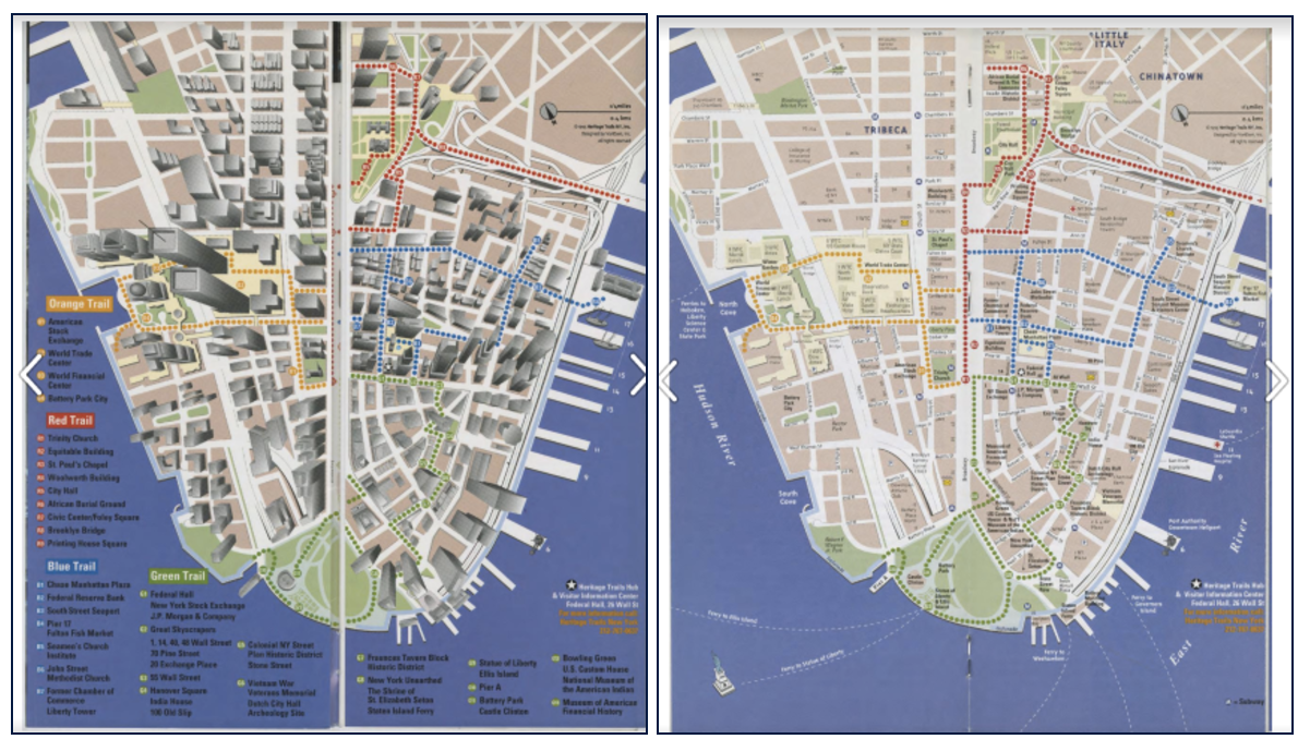
The Heritage Trails map that was featured in the 1995 launch brochure and appeared on the site markers was self-consciously innovative. Created by the cartographer Stephan Van Dam, who described it as a "sheared 4-point perspective,” the map shows both streets and buildings, which are represented in 3D. The goal was to give the map and visitors a sense both of the constricted spaces of Downtown and also clearly orient them to the streets and sights for way finding.
The first map of the trails created by Chermayeff & Geismar team was a standard 2D, figure-ground image with white streets and beige blocks. That map was also included in the 1995 launch brochure, but in the middle of the booklet, whereas the Van Dam map was placed in the front.
Not long before the June 1995 launch, Richard Kaplan had met Stephan Van Dam, and the two men were immediately simpatico. As Nadine Peyser recalled:
We had a lunch with Stephan and he was selling us this idea, the vertical city. Well, we all agreed this is such a vertical lower Manhattan that we needed to be able to get people comfortable on the street, but looking up. So the markers were a device to do that.
Keith Helmetag, who had created the first Chermayeff & Geismar map agreed that the Van Dam “3D” map were very successful, and popular with visitors, “because there was kind of a romance and kind of a human touch. They’re more user-friendly.” He also noted that he often observed tourists using the maps and concluded that they were more effective than the maps that later replaced them on refurbished markers.
Nadine Peyser also noted:
This was all very well thought through, this idea of opening the map, being able to – before you had iPhones – be able to really navigate having an index that was clear and being able to go in deeply and look at history and stories, making it very functional.
The unfolding of the map in a
VanDam, Inc.'s video illustrates the ideas.
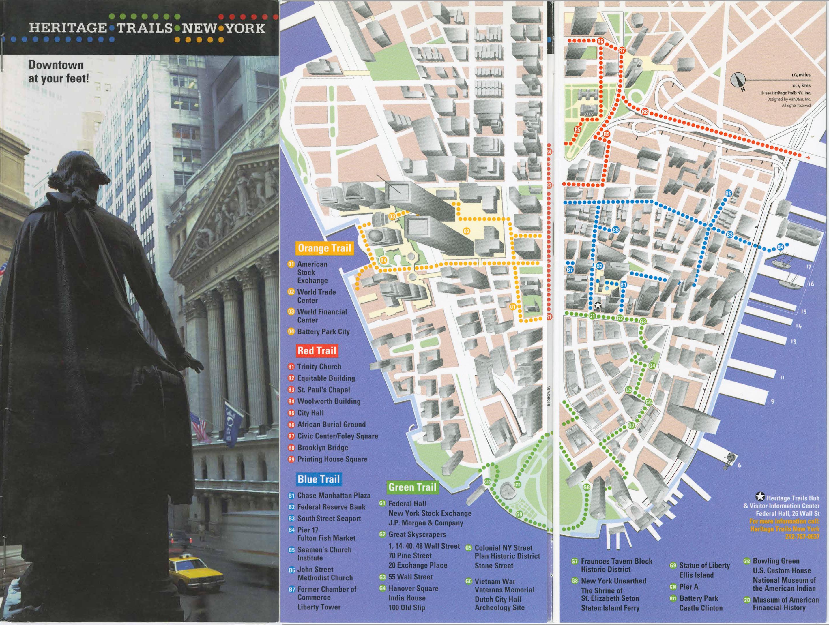
(c) 1995 Van Dam Map
The first version of Stephen Van Dam's map, which was included in the brochure available after the launch of Heritage Trails New York in June, 1995. The map would become a major part of Heritage Trails public identity. This early version included a marker to note the location of the Heritage Trails Hub & Visitor Information Center at Federal Hall.
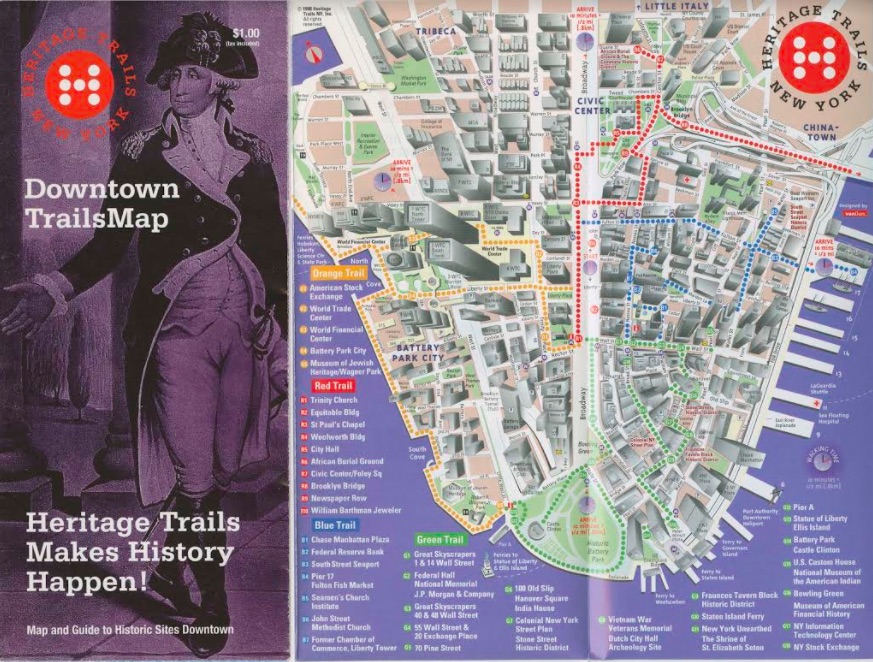
(c) 1998 Van Dam Map
An amended version of the VanDam Map, released after the physical site markers were installed in 1997. The map included more detailed labeling of downtown streets and buildings, estimated walking times for each trail, and the newly developed Heritage Trails logo in the upper right corner. Some changes were made to the order of the trails, such as the inclusion of
a walk down the esplanade from the World Trade Center to Wagner Park on the Orange Trail, and a number of additional sites on the Green Trail. The Skyscraper Museum's updated markers reflect this version of Heritage Trails.
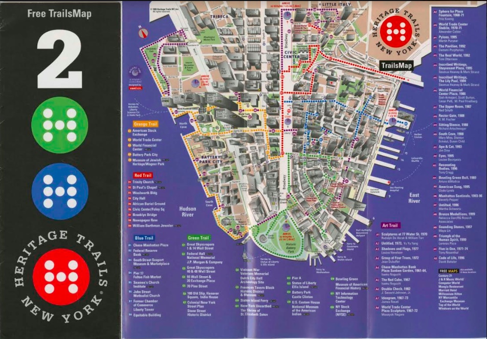
The final version of the map, ready for Heritage Trials in the 2000's, was amended to include the new Art Trail of Lower Manhattan. This would be the final version of the VanDam map used before Heritage Trails was taken over by the Downtown Alliance and rebranded.