
The Skyscraper Museum is devoted to the study of high-rise building, past, present, and future. The Museum explores tall buildings as objects of design, products of technology, sites of construction, investments in real estate, and places of work and residence. This site will look better in a browser that supports web standards, but it is accessible to any browser or Internet device.
br>
HERITAGE TRAILS PRECEDENTS
Heritage Trails New York had two significant precedents the 1976 New York City Heritage Trail and the 1951 Boston Freedom Trail. The 1990s Heritage Trails was also shaped by the Eyewitness guide books and was initiated two years after the radical Repo History had unveiled a temporary installation of signs about Lower Manhattan history entitled “The Lower Manhattan Sign Project.”
I think we realized what had not happened on the original Bicentennial trail, there was no physical marker on the ground. So that became important to us to think about how to demarcate trails.[4]
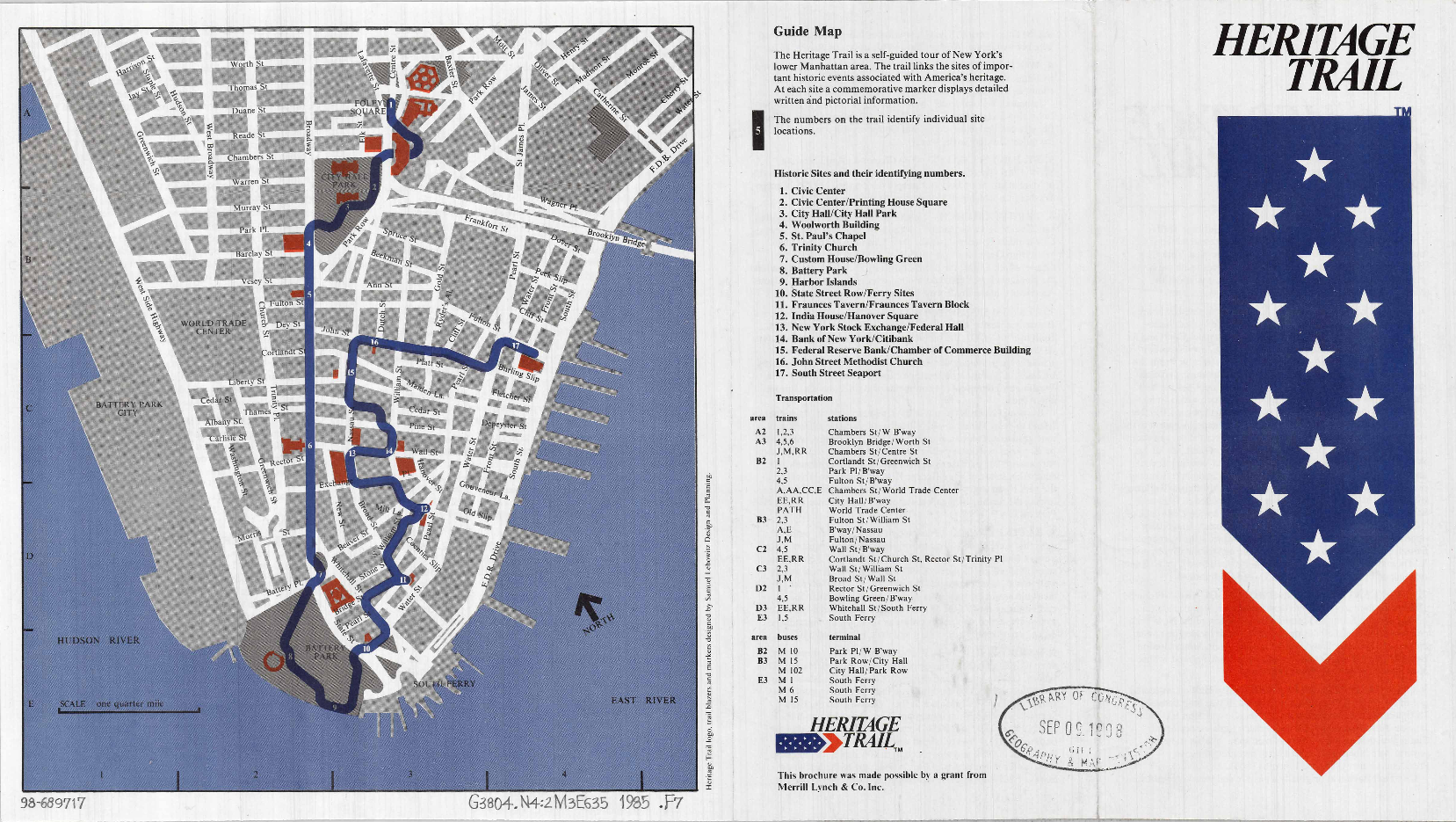
The 1990s Heritage Trails New York grew out of the 1976 Heritage Trail program, which was part of New York City’s Bicentennial celebration and was completed for July 4, 1976. According to Nadine Peyser: “And Heritage Trails came from…it was there in 1976, so that’s what we took over.”[1] The 1976 Heritage Trail consisted of 17 sites forming a loop that stretched from the Civic Center down to Battery Park before winding through downtown to catch buildings such as Fraunces Tavern and the New York Stock Exchange before ending at South Street Seaport. The self-guided tour consisted of trail blazer signs, which guided users along the trail, and markers by the 17 sites which had images and text pertaining to each site.[2] A brief brochure with a map, list of sites and a short summary of the significance of the site provided users with the route and information.[3]
Library of Congress
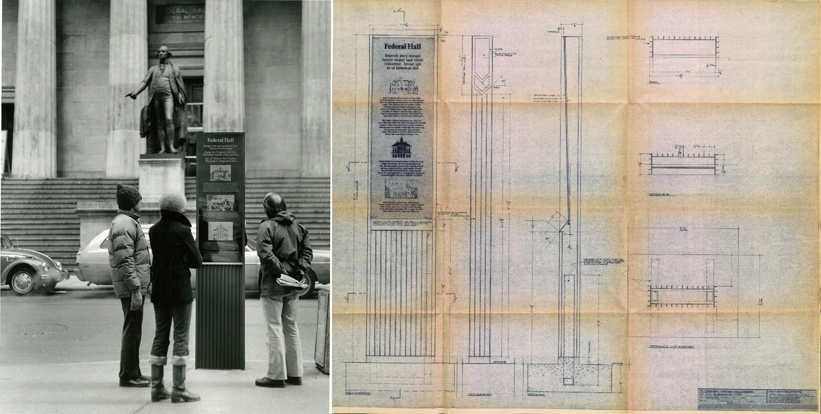
The markers, trailblazers and presumably the brochure were designed by Samuel Lebowitz. The markers were welded aluminum structural frames with flush riveted extruded aluminum ribbed skins finished dark bronze with an information sign with a dark bronze background, bright bronze text, illustrations and a silk screened HT symbol. While several of the 1976 markers were still in situ it was clear that HTNY was looking for a different style and tone from the older markers and had identified some of its drawbacks:
Library of Congress
Boston’s Freedom Trail, established in 1951, also formed an important precedent. The trail, which consists of 16 sites, has a continuous brick ribbon with metal markers reliefs identifying it as the Freedom Trail. Nadine Peyser stated:
I went up to Boston to talk about the Freedom Trails and to talk about their success because the one thing that has stuck is the Boston Freedom Trail.[5]
Boston’s Freedom Trail had succeeded in a way that the New York City 1976 Heritage Trail had not
Where Boston had that sense of every kid, every students, walks on the Freedom Trail. I think it was our hope to try to create on some level, sense of pride around this.[6]
Boston, however, had as a city paid for the creation of the Freedom Trail and its inlaid brick ribbon.. The grant-funded Heritage Trails New York did not have that kind of capitol to invest. According to designer Keith Helmetag:
The trail was kind of based on the Freedom Mile, but the Freedom Mile is inlaid, so it’s far more robust than this is. Once you click into the Freedom Trail in Boston, you’re really on point. This one, it’s a little tougher to chart.[7]
According to author and historian Tony Robins HTNY also wanted a different tone from the 1976 markers: “We knew they were there, but they were much more academic.”[8]
The Eyewitness guide became an precedent for the look of HTNY’s brochures and graphic identity. Nadine Peyser states:
So Eyewitness was a great visitor’s guide that we looked at as an example of what we thought was very cool. And it was the first guide to really use this kind of imagery or icons with text. So we decided for our map brochure that we wanted to create some sort of visual connection or icon so people could correlate between what they were seeing, what they were looking at, something to find.[9]
Just two years prior to the establishment of Heritage Trails. Repo History had unveiled a temporary year-long exhibit of 36 signs throughout Lower Manhattan. Unlike the ultimate focus of HTNY, Repo History emphasized a more subversive approach to history. Quote the J. P. Morgan sign. Historian Tony Robins stated: “Sure, we were aware of Repo History, and I later met the person who wrote that, Tom Klem. . .but he didn’t have anything to do with Heritage Trails.”[10] While different in intent and tone Repo Project’s Lower Manhattan Sign Project reasserted the significance of history for lower manhattan.