
The Skyscraper Museum is devoted to the study of high-rise building, past, present, and future. The Museum explores tall buildings as objects of design, products of technology, sites of construction, investments in real estate, and places of work and residence. This site will look better in a browser that supports web standards, but it is accessible to any browser or Internet device.
LOWER MANHATTAN LAND VALUES
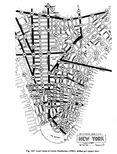
Map published in Richard M. Hurd,�Principles of City Land Values. New York: The Real Estate Record and Builders Guide, 1908. pg. 158
This 1903 map shows the wide range of land values across Lower Manhattan. The city's most expensive land, valued at $400 per square foot, was located on Wall Street at the �intersection of Broad and Nassau streets, where the�powerful financial institutions were�headquartered,�including the U.S. Sub-Treasury (in Federal Hall), the�New York Stock Exchange, and the offices of investment banker J. P. Morgan at 23 Wall, then in the Drexel Building. �The proximity and prestige of these�institutions and companies�drove the demand for a Wall Street address. High demand for the limited space produced high rents, high land values, and thus high-rise buildings, which clustered �in the financial district around Wall Street, on lower�Broadway, and near City Hall.�
Also notable on the map is the disparity between the high and low values. �Just a few blocks�west of Wall Street, land values plummeted to $10 a sq. ft., and�even along Wall Street near the East River, land values dropped to one-tenth the value of the premier blocks. The oft-repeated explanation for the island of Manhattan's skyscrapers- that buildings "grew upwards" because there was no room to "expand out," is contradicted by this 1903 map, which clearly shows the high prices that developers were willing to pay for some sites.